Google

Mount Agung, Bali

Mount Agung or Gunung Agung is a mountain in Bali. This stratovolcano is the highest point on the island. It dominates the surrounding area influencing the climate. The clouds come from the west and Agung takes their water so that the west is lush and green and the east dry and barren.
Gunung Agung last erupted in 1963-64 and is still active, with a large and very deep crater which occasionally belches smoke and ash. From a distance, the mountain appears to be perfectly conical, despite the existence of the large crater.
From the peak of the mountain, it is possible to see the peak of
Gunung Rinjani on the island of Lombok, although both mountains are frequently covered in cloud.


The 1963-64 Eruption
The lava flows missed, sometimes by mere yards, the Mother Temple of Besakih. The saving of the temple is regarded by the Balinese people as miraculous and a signal from the gods that they wished to demonstrate their power but not destroy the monument the Balinese faithful had erected. However, over 1,000 people were killed and a number of villages were destroyed in this eruption.

There are two routes up the mountain, one from Besakih which proceeds to a higher peak and starts at approximately 1100metres and another which commences higher from Pura Pasar Agung, on the southern slope of the mountain, near Selat and which is reputed to take 4 hours. There is no path between the two routes at the top. Cecilie Scott provides an account of the ascent from Pura Pasar Agung. The mountain can be seen from various directions in video, there is a well produced video of the climb from Pura Pasar Agung and a short video from the top above Besakih. Greg Slayden describes a climb from Besakih claimed to have taken a remarkable four and a half hours to the peak and Ken Taylor describes a climb that took much longer and which included getting lost.
Guides are available in Besakih and the mountain can also be climbed without a guide. The climb from Besakih is quite tough. It is sometimes tackled as a single climb generally starting about 10.00pm for a dawn arrival at the peak and sometimes with an overnight camp about three quarters of the way up. It is far harder than the more popular Balinese climb up Gunung Batur. It is not a mountain that needs ropes and not quite high enough for altitude sickness but adverse weather conditions develop quickly and warm waterproof clothing is required and should be carried. There is no water available along the route.
Proceed through the temple complex then continue on a path that travels continuously upwards on a steep narrow spur through open forest and jungle most of the way. There is little potential to get lost until the route opens up towards the top where the correct route doubles backwards. Many climbers miss this turn and continue up a small valley which can be climbed out of with some difficulty.


(From Wikipedia, free encyclopedia)

Mount Tangkuban Perahu, West Java


Tangkuban Perahu, or Tangkuban Parahu in local sundanese dialect, is an active volcano 30 km north of the city of Bandung, the provincial capital of West Java, Indonesia. It is a popular tourist attraction where tourists can hike or ride to the edge of the crater to view the hot water springs upclose, and buy eggs cooked on its hot surface. This stratovolcano is on the island of Java and last erupted in 1983.
In April 2005 the Directorate of Volcanology and Geological Hazard Mitigation raised an alert, forbidding visitors from going up the volcano. "Sensors on the slopes of the two mountains - Anak Krakatoa on the southern tip of Sumatra Island and Tangkuban Perahu in Java - picked up an increase in volcanic activity and a build up of gases, said government volcanologist Syamsul Rizal."

Local Legend of the Mountain
The name translates roughly to "upturning of (a) boat" or "upturned boat" in Sundanese, referring to the local legend of its creation. The story tells of "Dayang Sumbi", a beauty who lived in West Java. She cast away her son "Sangkuriang" for disobedience, and in her sadness was granted the power of eternal youth by the gods. After many years in exile, Sangkuriang decided to return to his home, long after the two had forgotten and failed to recognize each other. Sangkuriang fell in love with Dayang Sumbi and planned to marry her, only for Dayang Sumbi to recognize his birthmark just as he was about to go hunting. In order to prevent the marriage from taking place, Dayang Sumbi asked Sangkuriang to (1) build a dam on the river Citarum and (2) build a large boat to cross the river, both before the sunrise. Sangkuriang meditated and summoned mythical ogre-like creatures -buta hejo or green giant(s)- to do his bidding. Dayang Sumbi saw that the tasks were almost completed and called on her workers to spread red silk cloths east of the city, to give the impression of impending sunrise. Sangkuriang was fooled, and upon believing that he had failed, kicked the dam and the unfinished boat, resulting in severe flooding and the creation of Tangkuban perahu from the hull of the boat.

From Wikipedia, the free encyclopedia

Mount Semeru, East Java


Semeru, 1985
Elevation : 3,676 metres (12,060 feet)
Location : Java, Indonesia
Prominence : 3,676 m
Coordinates : 8°6′28.8″S, 112°55′12″E
Type : Stratovolcano (active)
Last eruption : 2006 (continuing)


Semeru also Gunung Semeru - is the tallest mountain on the island of Java and one of its most active volcanoes. Known also as Mahameru (Great Mountain), it is very steep and rises abruptly above the coastal plains of eastern Java. Maars containing crater lakes have formed along a line through the summit. Semeru lies at the south end of the Tengger Volcanic Complex.
Semeru's eruptive history is extensive. Since 1818, at least 55 eruptions have been recorded (10 of which resulted in fatalities) consisting of both lava flows and pyroclastic flows. Moderate explosive eruptions (VEI 2-3) have also been recorded with some regularity.
Semeru has been in a state of near-constant eruption from 1967 to the present. At times, small eruptions happen every 10 minutes or so.
Semeru is regularly climbed by tourists, usually starting from the village of Rano Pani to the north, but though non-technical it can be dangerous. Soe Hok Gie, an Indonesian political activist of the 1960s died in 1969 from inhaling poisonous gas while hiking on Mount Semeru.


Semeru is named from Sumeru, the central world-mountain in Buddhist cosmology. In legend it was transplanted from India; the tale is recorded in the 16th-century East Javanese work Tantu Panggelaran. It was originally placed in the western part of the island, but that caused the island to tip, so it was moved eastward. On that journey, parts kept coming off the lower rim, forming the mountains Lawu, Wilis, Kelut, Kawi, Arjuno and Welirang. The damage thus caused to the foot of the mountain caused it to shake, and the top came off and created Penanggungan as well.


From Wikipedia, the free encyclopedia
(Redirected from
Mount Semeru)


Mount Tambora, Sumbawa

Mount Tambora (or Tomboro) is an active stratovolcano on Sumbawa island, Indonesia. Sumbawa is flanked both to the north and south by oceanic crust, and Tambora was formed by the active subduction zones beneath it. This raised Mount Tambora as high as 4,300 m (14,000 ft),[2] making it one of the tallest peaks in the Indonesian archipelago, and drained off a large magma chamber inside the mountain. It took centuries to refill the magma chamber, its volcanic activity reaching its peak in April 1815.[3]
Tambora erupted in 1815 with a rating of seven on the Volcanic Explosivity Index; the largest eruption since the Lake Taupo eruption in AD 181.[4] The explosion was heard on Sumatra island (more than 2,000 km or 1,200 mi away). Heavy volcanic ash falls were observed as far away as Borneo, Sulawesi, Java and Maluku islands. The death toll was at least 71,000 people, of which 11,000–12,000 were killed directly by the eruption;[4] most authors estimated 92,000 people were killed but this figure is based on an overestimated calculation.[5] The eruption created global climate anomalies; 1816 became known as the Year Without a Summer because of the effect on North American and European weather. Agricultural crops failed and livestock died in much of the Northern Hemisphere, resulting in the worst famine of the 19th century.[4]
During an excavation in 2004, a team of archaeologists discovered cultural remains buried by the 1815 eruption.[6] They were kept intact beneath the 3 m (10 ft) deep pyroclastic deposits. Dubbed the Pompeii of the East, the artifacts were preserved in the positions they had occupied in 1815.

References
^
a b c Tambora. Global Volcanism Program. Smithsonian Institution. Retrieved on 2006-10-07.
^
a b c d e f g h i j k l m n Stothers, Richard B. (1984). "The Great Tambora Eruption in 1815 and Its Aftermath". Science 224 (4654): 1191–1198.
^
a b c Degens, E.T.; Buch, B (1989). "Sedimentological events in Saleh Bay, off Mount Tambora". Netherlands Journal of Sea Research 24 (4): 399–404.
^
a b c d e f g h i j k l m n o Oppenheimer, Clive (2003). "Climatic, environmental and human consequences of the largest known historic eruption: Tambora volcano (Indonesia) 1815". Progress in Physical Geography 27 (2): 230–259.
^
a b c Tanguy, J.-C.; Scarth, A., Ribière, C., Tjetjep, W. S. (1998). "Victims from volcanic eruptions: a revised database". Bulletin of Volcanology 60 (2): 137–144.
^
a b c d e University of Rhode Island (2006-02-27). URI volcanologist discovers lost kingdom of Tambora. Press release. Retrieved on 2006-10-06.
(From Wikipedia, the free encyclopedia
Photo courtesy from www.uri.edu)

Mount Karangetang, Siau Island, North Sulawesi

Photo courtesy of Vulcani & Vulcani, Italy
Location: 2.78°N, 125.48°EElevation: 5850 ft. (1784 m)Last Updated: February 25, 2005

The Karangetang volcano is also known as Api Siau and is located on the northern end of Siau Island. The island is home to five summit craters. Karangetang is one of Indonesia's most active volcanoes. Since 1675, forty eruptions have been recorded. This is one of A type active volcanoes in North Sulawesi -Sangihe Islands volcanic arc, and located in the northern part of Siau Island. In 1974, during Karangetang's last major eruption, the entire population of Siau was forced to evacuate the island. Pyroclastic flow hazard have been noticed since the 1967 explosion, then in 1984-1985, 1988, 1992 and 1996. So far, the largest victims were 6 persons which were killed by a pyroclastic flow of the May 18, 1992 eruption. They were usually killed because of heat or at least heat injured. Lahars occurred in rivers after eruption producing pyroclastic flow deposits. Karangetang Volcano is a conical shape with average slope about 25, and has two peaks, i.e. South Peak (1827 m) and North Peak (1784 m). Crater I is situated at the South Peak (Mardiasto, 1952; Semeru Harto, 1962; see Kusumadinata 1979; Manalu, 1986), whereas crater IV is located at the North Peak. Crater III is positioned in the saddle between the two peaks. Due to the continues activity crater IV, as the main crater, was formed inside the crater I. In 1996, both craters I and IV have been fully occupied by a lava dome. Karangetang Volcano has also flank craters, two in the south (+ 100 m and + 800 m) and one in the northwest (+ 950 m) slopes. The first two craters were formed during eruptions on September 15 and17, 1979 (Manalu, 1986), while the third one was on May 31, 1979(Pardyanto, 1981), and is known as Batubulan crater.
There is an island myth that says that the trees that surround the Karangetang were those that created it. Mysteriously the roots of the highest trees went towards a small hill and formed Karangetang (its form) and the roots went to the center and opened the Earth.
Photo courtesy of the Directorate of Volcanology and Geological Hazard Mitigation
Photographed by S.R.Wittiri

From Wikipedia, the free encyclopedia

Mount Bromo, East Java


Mount Bromo also Gunung Bromo, located in the Tengger Caldera, is one of the most popular tourist attractions in East Java, Indonesia. It is an active volcano and part of the Tengger massif, and even though at 2329 meters it is not the highest peak of the massif, it is the most well known.


According to a local folk tale, at the end of the 15th century princess Roro Anteng from the Majapahit Empire started a separate principality together with her husband Joko Seger. They named it Tengger by the last syllables of their names. The principality did prosper, but the ruling couple failed to conceive children. In their despair they climbed Mount Bromo to pray to the gods, who granted them help, but requested the last child to be sacrificed to the gods. They had 24 children, and when the 25th and last child Kesuma was born Roro Anteng refused to do the sacrifice as promised. The gods then threatened with fire and brimstone, until she finally did the sacrifice. After the child was thrown into the crater, the voice of the child ordered the local people to perform an annual ceremony on the volcano, which is not held today.

(From Wikipedia, the free encyclopedia)

Mount Gede, West Java

Gunung Gede and Pangrango are the first five parks that had distinction of launching Indonesias National Park Program. Located on Bogor, Cianjur and Sukabumi districts with cover area around 15,196 ha. It is the most accessible mountain to climb from Jakarta. By only 2 hours drive south of Jakarta and 5 " 6 hours trekking, you will find a tranquil rainforest, self guided trail and a spectacular view of West Java from the peak.

The national park consists of twin volcanoes: Gede 2958 m above sea level (asl) and Pangrango 3019 asl. The two summits are connected by a high saddle known as Kandang Badak, 2400 m asl. The mountain slopes are very steep and are cut info rapidly flowing stream, which carve deep valleys and long ridges.
For those fortunate enough to stand on the summit of Mount Gede in clear conditions the view is spectacular. Some people, including, it is said, Raffles, have claimed to be able to see the Java Sea to the north and the Indian Ocean to the south. Occasionally climbers with very good eyesight or maybe imagination " have sighted Sumatra on the west! Mount Pangrango is less scenery, but more rich in flora than Mount Gede.


Mount Kelud, East Java

Mount Kelud tourism area is about 40 km, 45 Minutes from Kediri City. Kelud is a volcano. Breezes of fresh air and charming scenery make this area interesting for ecotourism, adventuring, and health purposes. Here we can enjoy the shady cool plantation, an area for rock climbing, jogging, cross country, and camping ground, a channel to the crater through the mountain, sulfur lake down the mountain volcanology information service, and entertainment performances on weekends / holidays.Mount Kelud is a relatively small stratovolcano with a summit elevation at 1731m above sea level or 1650m above the densely populated and fertile plains of Kediri and Blitar that surround the volcano. Kelud volcano is located at about 27 km from Kediri city and lies between the volcanic massif of Mount Wilis to the West and the complex of Kawi and Butak volcanoes to the East. Kelud volcano is considered as one of the most dangerous volcanoes of Java because of its frequent eruptions. The eruptive activity has typically generated deadly lahars, pyroclastic flows and surges that have claimed more than 15,000 lives since 1500 AD and caused widespread fatalities and destruction. The crater lake of Kelud is famous for its potential to release devastating lahars whenever an eruption occurs. The 1586 eruption produced one of the worst lahar in the historical record of volcanic eruptions and took the lives of about 10,000 people. Extensive works to control lahars have been achieved around the volcano. A system of drainage of the Crater Lake was completed in 1926. Today, this drainage tunnel still works and maintains the volume of the lake at a low level (2 million m3). Several dams were also built on the slopes of this volcano in order to protect the largest towns. The tourism objects of mount Kelud:- Ampera tunnel 110 m comes out at the Gajah Mungkur top was built in 1940 by Japanese; the function is to drain the lava.- The cauldron of Mount Kelud that is believed by society can make peaceful and prosperity.- The top of Sumbing, which was the characteristic of slope rocks structure with 90 % declining, used as medium for wall climbing. - The observation posts of mount Kelud.-The ritual ceremony of Larung Sesaji in cauldron of Mount Kelud is held every September.

Mount Gamkonora, North Maluku

Thousands of Indonesians have been evacuated from the slopes of a volcano that is spewing out hot ash and smoke in the east of the country.
The alert around Mount Gamkonora, in North Maluku province, has been raised to its highest level amid fears a major eruption could be imminent.
Scientists have reported seeing fire and ash clouds rising as high as 4,000m (13,100ft) since Monday.
Some 8,400 villagers have been moved to special camps away from the volcano.
However, scientists are warning that lava could still reach the camps if there is a large eruption - and have advised residents to wear face masks to protect themselves from the ash clouds.
Some 2,000 people are reported to have chosen to remain within the 8km (five mile) danger zone marked out by officials.

'Ring of Fire'
Activity at the 1,635m mountain rose sharply on Monday, prompting scientists to raise the alert level.
Saut Simatupang of Indonesia's Vulcanological Survey told Reuters news agency that the volcano was spitting out volcanic ash as high as 4,000m at its peak on Monday.

He said there had been less smoke and ash on Tuesday "but that does not mean the volcano is safe".
Mt Gamkonora is the highest peak on the island of Halmahera in North Maluku province, some 2,400km east of the Indonesian capital Jakarta.
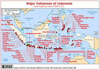
It is one of at least 120 active volcanoes in Indonesia, which is part of the Asia-Pacific "Ring of Fire", a series of volcanoes and fault lines stretching from the Western Hemisphere through Japan and South East Asia.
(from : www.lampholderpub.com)

Mount Krakatau, Sunda Strait

At some point in the distant past, Krakatau consisted of a single, large volcanic island. This island was destroyed in eruptions presumably of great violence, leaving three fragments of the original volcanic walls in a broken ring, or caldera, around the edge of this original island. The three islands are now named Rakata, Sertung and Panjang. Subsequently, further eruptions began, building up the largest island (Rakata) back into the center
of the caldera. As of 1883, the only previous recorded eruptions had come from this big island in 1680. The islands of Panjang and Sertung, then as now, remained dormant. Then in May of 1883, eruptions began again on the big island, and one by one, the three peaks of the island -- Perboewatan, Danan and Rakata -- each came into action as the cycle of building and destruction reached its peak. Finally, on August 27th, the sequence ended in catastrophe, as huge volumes of ejecta were hurled into the sky, plunging the surrounding region for a radius of 80 km into 57 hours of darkness. Relatively few people appear to have died as a direct result of the ejecta, but huge numbers died because of an indirect consequence of the eruption. As the magma chamber emptied, the outer walls of the volcano failed, and collapsed -- repeating the pre-historic caldera collapse -- displacing two-thirds of the island. These events generated a series of giant waves, or tsunami, which steepened as they reached shallow waters. These waves swept across the coastal lowlands of Java and Sumatra on either side of the Sunda Strait, killing an estimated 36,000 people and destroying many settlements. As an illustration of the forces involved, a government gunboat, the Berouw, was carried nearly 3 km inland and stranded behind a small hill 9 m above sea-level (the crew of 28 were amongst those who died). The violence ended abruptly, leaving a greatly re-shaped archipelago. In the centre of the caldera, where there had once been a substantial island, the sea-floor was reached at a depth of over 250 m. The three remaining islands were greatly re-shaped, and in places extensive new land surfaces had been created by the deposition of great thicknesses of pyroclastic ashes where once had been nothing but the sea. On the persisting areas of land, an average of 60-80 m of these ashes had been emplaced. The resulting landscapes were completely barren, and as far as can be established, no life survived. Plants and animals soon colonized, and the ecosystem re-building began -- a story we will come back to. Down in the depths of the earth, the emptied magma chamber will, once again, have begun to fill, eventually creating sufficient pressure to begin the construction phase of the cycle once again, naturally, pretty much in the center of the caldera.

Mount Talang, West Sumatera


The summit of forested volcano Talang, seen here from the NW, lacks a crater,although two craterlakes occur on the flanks of the volcano.Several flank eruptions took place in the 19th century.Anonymous photo 1991


Talang, on the island of Sumatra in the Ecah province, is located exactly at 0°58'42"S and 100°40'46"E. The summit elevation is 2.597m (8.520 feet).Talang, which forms a twin volcano with the extinct Pasar Arbaa volcano, has two craterlakes on its flanks. The largest of these is 1 x 2 km wide Danau Talang. No historical eruptions have occurred from the summit of the volcano, which lacks a crater. All historical eruptions from Gunung Talang volcano have involved small-to-moderate 19th-century explosive activity originating from a series of small craters in a valley on the upper NE flank.and three smaller eruptions in 1981, 2001 and 2003. Friday, April 15th, 2005Last 24 hours estimated SO2 mass was around 1000 tonnes (Simon Carn) . Seismograph recorded shallow & deep volcanic quakes and tectonicWednesday, April 13th, 200511.30 UTC: Related government officials, using buses and trucks, have continued to evacuatethousands of residents from the slopes of Mount Talang volcano,''according to the localnatural disaster coordination office in the West Sumatra district of Solok. Volcanology expertsat the nearby monitoring centre reported that continued eruptions from Mount Talang havebeen accompanied by tremors that were shaking nearby areas. 09.00 UTC: There was new panic on Wednesday as a volcanic earthquake struck Talang at 10:00 am (0300 GMT), causing many to rush out of the buildings, mosquesand schools that they have been sheltering in since evacuating their villages.Talang volcano on Sumatra island erupted on Tuesday sending hot ash high into the air and forcing the evacuation of hundreds of villagers.
The eruption was accompanied by a string of moderate earthquakes that rattled towns in Sumatra, which is still recovering from massive Dec.26 quake and tsunami on its northern end.Vulcanologists said they could not confirm whether lava had actually spewed out. But smokehad billowed up to 1,000 meters (3,280 ft) high from the volcano's crater and ash had traveled up to 12 km (7.5 miles) away. Other reports say that Talang volcano sent ash to8,000 m asl (25,000 ft.) Indonesia’s President depart Jakarta Air Force Base at 10:00 am to Padang, to visitSumatra volcano refugees. Latest report said that the more than 27,000 people had beenevacuated from villages surrounding the Talang, at Solok district of West Sumatra province.The number is likely to increase because there are many others who have not been evacuated. Official has also raised the alert level on Wednesday as the mountain's activity intensified.

Mount Kerinci, West Sumatera


Location: 1.7S, 101.3E
Elevation: 12,480 feet (3,805 m)


Kerinci is a stratovolcano on the island of Sumatra. Kerinci has erupted at least twenty times since 1838. The most recent confirmed eruption was in 1969-1970. An unconfirmed eruption was reported in 1971.
Most eruptions at Kerinci are small to moderate in size (VEI=1-2) and explosive. Because of the presence of the crater lake there have been several phreatic eruptions. Seismicity at Kerinci was dominated by small explosion earthquakes. On August 27 at 10:00, an ash plume was observed at a height of approximately 3.5 kilometers above sea level.

This information was summarized from the GVP/USGS Weekly Volcanic Activity Report. This photo shows the crater lake of Kerinci and the wall of the crater. Photograph by C. Ollier.

Smoking cone of Gunung Kerinci (Indrapura), 3800m active volcano which dominates 1.5 million hectare Kerinci-Seblat National Pk Biosphere Reserve & highest peak in Sumatra, Indonesia. Volcano contributes to fertility of ecosystem, valley farms. I20.24s (from : www.ecopix.net)

Mount Galunggung, West Java


Galunggung is a stratovolcano on the west side of the island of Java. The caldera of Galunggung is open to the southeast. The first historic eruption of Galunggung was in 1822. Since then the volcano has erupted four times, most recently in 1984. This photo shows a column of ash rising above the summit during the large (VEI=4) Vulcanian-type eruption.
Eruption columns at Galunggung reached heights as great as 15 miles (24 km). Two eruptions at Galunggung have caused fatalities. During the 1822 eruption (VEI=5), nuee ardentes and mudflows killed 4,011 people and destroyed 114 villages. The nuee ardentes extended up to 6 miles (10 km) away from the volcano. During the 1982 eruption (VEI=4) about 68 people died, mostly from indirect causes (traffic accidents, old age, cold, and lack of food). Estimated damage was $15 million and 22 villages were left uninhabitable. The 1984 eruption was phreatic and lasted about two weeks. This photo shows lightning above the summit and glowing pyroclasts on the flank of Galunggung. The April 1982-January 1983 eruption destroyed the 1918 lava dome and produced a new cinder cone in a new crater. The crater was about 2,000 feet (600m) across and about 1,000 feet (300 m) deep. The cone grew to 250 feet (75 m) and was 650 feet (200 m) in diameter. View of new cinder cone. As the 1982-1983 eruption waned a crater lake began to form. The presence of the lake, high rainfall, and the large volume of exposed pyroclastic material on the volcano have made the hazard associated with secondary lahars very high. The lahar deposits have been revegitated and a lahar warning system has been established.
During the 1982 eruption two jumbo jets entered the ash clouds at an altitude of about 6 miles (10 km). Their engines stalled and windshields were abraded. Fortunately, the pilots were able to restart the engines.
Photo by Jack Lockwood, U.S. Geological Survey, September 16, 1982; October 30, 1982; July 31, 1982 (www.volcano.und.edu)

Mount Rinjani, West Nusa Tenggara

Rinjani is an active volcano that built the island of Lombok along the Indonesian fault. I think that is a realistic way of looking at the role of a volcano. When anyone mentions Rinjani they always say it is on the island of Lombok. Wrong. The island is on the volcano and consequently on the tectonic plate fault line that has spawned the longest and most active line of volcanic reactions on earth. Everybody who lives on the island of Lombok owes their existence and their livelihood to the volcano. The inevitable if irregular eruptions not only created the land they stand on, but also enrich the soil for a bountiful harvest. With the tropical rains that fall on the island come the lush emerald green forests and terraced rice fields that symbolize this exotic region of Indonesia.

Ying and Yang, good and evil, life and death, and all the other polar opposites best describe the condition of living on Lombok or within the vicinity of any other volcano for that matter. Shaken by the sporadic and unpredictable eruptions, it’s no wonder that the people of Lombok worship the spirit of the fiery inverted-cone shaped mountain. They celebrate its very existence and are careful not to enrage the spirits in charge. Don’t rock the boat. Don’t spit into the wind. And don’t tug on Superman’s cape. I don’t think I could live like that. Always tip toeing around your creator. Always being a quiet good little boy as not to wake your step-dad. Always offering to light the alter candles. Forever throwing white rice, green banana leaves, and saffron coloured flowers into the abyss. Although I took out my Grandma’s garbage on a regular basis, I was always the one to rise to the challenges of our neighbourhood. For example, I led the raid on old man Apsit’s garden. Not just because he had the best garden around, but mostly because he guarded it so jealousy. He basically told us we were not allowed to go there. Mistake. What is so tempting about the 12,296 ft Rinjani volcano, however, is that somewhere in the distant past an enormous explosion tore off the top of the 15,000 ft volcano and left a gaping crater large enough to place a small city within. With thousands of years of tropical rain the vast crater basin now holds the large beautiful Segara Anak Lake whose surface sits at about 6,300 ft elevation above sea level. Both the Balinese and the Muslim Sasak of Lombok Island make a pilgrimage to toss ritual rice and goldfish into the clear mountain waters. At the risk of appearing irreverent I will say that this scared lake was begging for a bushpilot to pay homage.


Lake Segara Anak is about five km long and three km wide with a 200 year old secondary cone protruding out of the east end. Adding to the expansive feeling of grandeur the surrounding crater rim extends upward another three to four thousand feet to create a continuous enclosure looking so much like a crumbled wall of an ancient Roman coliseum. The only exception is where the initial explosion, or later erosion, created a narrow gap in the north end. Here the excess rainwater flows out forming a waterfalls and a river that flows to the sea. The normal way of getting to this wondrous lake and for that matter to the volcano peak is to hike up. Time magazine did a feature on this particular climb in 2001 and declared it to be difficult, treacherous, and extremely worthwhile. The adventure is akin to climbing Mt. Kilimanjaro, but tougher. It takes two days of slogging up a tropical rainforest trail complete with heat, insects, thieving monkeys, and washed out footpaths. On the morning of the second night you awake early to make the rim at sunrise. Here you can view the lake at its most serene before the inevitable mountain top clouds form to cover the basin for the remainder of the day. If you want you can hike down nearly 3,000 feet to the lakeside campsite, but few hikers do. Even fewer actually make it to the 12,296 foot summit.

www.abushpilot.com(Article and Images by John S Goulet)

Mount Batur Caldera, Bali

Batur caldera is situated in the north eastern part of Bali Island, and about 70 km north of the capital city of Denpasar. There are six main routes of travel to the caldera that can be attained from Denpasar and one route from Singaraja. The most useable of these is the road from Denpasar to Kintamani passing Bangli city.
Batur caldera is one of the finest calderas in the world, about 13.8 by 10 kilometers ( Van Bemmelen, 1949) with another circular composite collapse structure with a diameter of 7.5 km formed in its center. The rim varies in height from 1267 to 2152 meters (the marginal cone of Mount Agung ). Within caldera is the active strato volcano of Batur volcano and a lake. The highest peak of Batur volcano is about 1717 m above sea level and 686 m above the surface of lake Batur, and is located at 8°14’ 30’’ S and 115°22’30’’ E ( van Padang, 1951 ; Kusumadinata,1979 ).
Adapted from : www.baliwww.com (April 10th, 2006 by ablteam)

Mount Merapi, Yogyakarta, Central Java

Merapi Elevation 2,914 metres (9,616 ft) Location Central Java (Indonesia) Coordinates 7°32′S, 110°26′E Type Stratovolcano Age of rock 400,000 years Last eruption 2006


Mount Merapi, Gunung Merapi in Indonesian language, is a conical volcano in Central Java, Indonesia. It is the most active volcano in Indonesia and has erupted regularly since 1548. Its name means Mountain of Fire. It is very close to the city of Yogyakarta, and thousands of people live on the flanks of the volcano, with villages as high as 1700 m above sea level.
Several of its eruptions have caused fatalities. It was erupting from 1992 to 2002, and a particularly large explosion killed 43 people in 1994. It began erupting again in 2006, and scientists believe a large eruption is imminent. In light of the hazards it poses to populated areas, it has been designated a Decade Volcano.
Merapi is the youngest in a group of volcanoes in southern Java.It is situated at a subduction zone, where the Indo-Australian Plate is sliding beneath the Eurasian Plate. It is one of at least 129 active volcanoes in Indonesia, part of the Pacific Ring of Fire - a section of fault lines stretching from the Western Hemisphere through Japan and South East Asia.[1] Stratigraphic analysis reveals that eruptions in the Merapi area began about 400,000 years ago, and from then until about 10,000 years ago, eruptions were typically effusive, and the outflowing lava emitted was basaltic. Since then, eruptions have become more explosive, with viscous andesitic lavas often generating lava domes. Dome collapse has often generated pyroclastic flows, and larger explosions, which have resulted in eruption columns, have also generated pyroclastic flows through column collapse.
Typically, small eruptions occur every two to three years, and larger ones every 10-15 years or so. Notable eruptions, often causing many deaths, have occurred in 1006, 1786, 1822, 1872 (the most violent eruption in recent history), and 1930—when thirteen villages were destroyed and 1400 people killed by pyroclastic flows.
A very large eruption in 1006 is claimed to have covered all of central Java with ash. The volcanic devastation is claimed to have led to the collapse of the Hindu Kingdom of Mataram, however there is insufficient evidence from that era for this to be substantiated.
Merapi continues hold particular significance for the Javanese: it is one of four places where officials from the royal palaces of Yogyakarta and Solo make annual offerings to placate the ancient Javanese spirits.

From Wikipedia, the free encyclopedia (Redirected from Mount Merapi, Central Java)