Mount Kerinci, West Sumatera

Location: 1.7S, 101.3E
Elevation: 12,480 feet (3,805 m)
Kerinci is a stratovolcano on the island of Sumatra. Kerinci has erupted at least twenty times since 1838. The most recent confirmed eruption was in 1969-1970. An unconfirmed eruption was reported in 1971.
Most eruptions at Kerinci are small to moderate in size (VEI=1-2) and explosive. Because of the presence of the crater lake there have been several phreatic eruptions. Seismicity at Kerinci was dominated by small explosion earthquakes. On August 27 at 10:00, an ash plume was observed at a height of approximately 3.5 kilometers above sea level.
This information was summarized from the GVP/USGS Weekly Volcanic Activity Report. This photo shows the crater lake of Kerinci and the wall of the crater. Photograph by C. Ollier.
 Smoking cone of Gunung Kerinci (Indrapura), 3800m active volcano which dominates 1.5 million hectare Kerinci-Seblat National Pk Biosphere Reserve & highest peak in Sumatra, Indonesia. Volcano contributes to fertility of ecosystem, valley farms. I20.24s (from : www.ecopix.net)
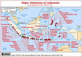

Tidak ada komentar:
Posting Komentar