Mount Rinjani, West Nusa Tenggara
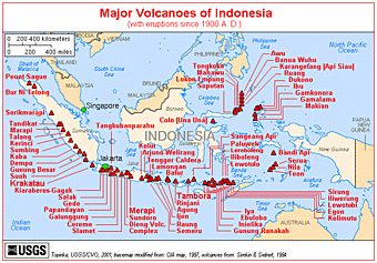
 Rinjani is an active volcano that built the island of Lombok along the Indonesian fault. I think that is a realistic way of looking at the role of a volcano. When anyone mentions Rinjani they always say it is on the island of Lombok. Wrong. The island is on the volcano and consequently on the tectonic plate fault line that has spawned the longest and most active line of volcanic reactions on earth. Everybody who lives on the island of Lombok owes their existence and their livelihood to the volcano. The inevitable if irregular eruptions not only created the land they stand on, but also enrich the soil for a bountiful harvest. With the tropical rains that fall on the island come the lush emerald green forests and terraced rice fields that symbolize this exotic region of Indonesia.
Ying and Yang, good and evil, life and death, and all the other polar opposites best describe the condition of living on Lombok or within the vicinity of any other volcano for that matter. Shaken by the sporadic and unpredictable eruptions, it’s no wonder that the people of Lombok worship the spirit of the fiery inverted-cone shaped mountain. They celebrate its very existence and are careful not to enrage the spirits in charge. Don’t rock the boat. Don’t spit into the wind. And don’t tug on Superman’s cape. I don’t think I could live like that. Always tip toeing around your creator. Always being a quiet good little boy as not to wake your step-dad. Always offering to light the alter candles. Forever throwing white rice, green banana leaves, and saffron coloured flowers into the abyss. Although I took out my Grandma’s garbage on a regular basis, I was always the one to rise to the challenges of our neighbourhood. For example, I led the raid on old man Apsit’s garden. Not just because he had the best garden around, but mostly because he guarded it so jealousy. He basically told us we were not allowed to go there. Mistake. What is so tempting about the 12,296 ft Rinjani volcano, however, is that somewhere in the distant past an enormous explosion tore off the top of the 15,000 ft volcano and left a gaping crater large enough to place a small city within. With thousands of years of tropical rain the vast crater basin now holds the large beautiful Segara Anak Lake whose surface sits at about 6,300 ft elevation above sea level. Both the Balinese and the Muslim Sasak of Lombok Island make a pilgrimage to toss ritual rice and goldfish into the clear mountain waters. At the risk of appearing irreverent I will say that this scared lake was begging for a bushpilot to pay homage.

Lake Segara Anak is about five km long and three km wide with a 200 year old secondary cone protruding out of the east end. Adding to the expansive feeling of grandeur the surrounding crater rim extends upward another three to four thousand feet to create a continuous enclosure looking so much like a crumbled wall of an ancient Roman coliseum. The only exception is where the initial explosion, or later erosion, created a narrow gap in the north end. Here the excess rainwater flows out forming a waterfalls and a river that flows to the sea. The normal way of getting to this wondrous lake and for that matter to the volcano peak is to hike up. Time magazine did a feature on this particular climb in 2001 and declared it to be difficult, treacherous, and extremely worthwhile. The adventure is akin to climbing Mt. Kilimanjaro, but tougher. It takes two days of slogging up a tropical rainforest trail complete with heat, insects, thieving monkeys, and washed out footpaths. On the morning of the second night you awake early to make the rim at sunrise. Here you can view the lake at its most serene before the inevitable mountain top clouds form to cover the basin for the remainder of the day. If you want you can hike down nearly 3,000 feet to the lakeside campsite, but few hikers do. Even fewer actually make it to the 12,296 foot summit.


Tidak ada komentar:
Posting Komentar