Google

Volcanoes in Indonesia

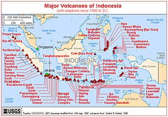
The archipelago of Indonesia consists of more than 13,000 islands, spread over an area that is similar in size to that of the continental United States. It is the country with the greatest number and density of active volcanoes.
Most volcanoes in Indonesia belong to the Sunda Volcanic Arc, streching over 3,000 kilometers from NW Sumatra to the Banda Sea. This volcanic arc results from the subduction of Indian Ocean crust beneath the Asian Plate and includes 76% of the region's volcanoes. To the NNW, the basaltic volcanism of the Andaman Islands results from short spreading centers, and to the east the Banda Arc reflects Pacific Ocean crust subducted westward. North of this arc, the tectonic setting is much more complex: several fragments of plates are converging to form multiple subduction zones, mainly oriented N-S. These produce the Sulawesi-Sangihe volcanoes on the west and Haimahera on the east of the collision zone.
Indonesia leads the world in many volcano statistics. It has the largest number of historically active volcanoes (76), its total of 1,171 dated eruptions is only narrowly exceeded by Japan's 1,274, although not much is know about the volcanic activity in the time before European colonialists arrived from the 15th century on. Indonesia has suffered the highest numbers of eruptions producing fatalities, damage to arable land, mudflows, tsunamis, domes, and pyroclastic flows. Four-fifths of Indonesian volcanoes with dated eruptions have erupted in this century.
Two of the most devastating volcanic eruptinos in historic time took place in Indonesia: the enormous eruption of Tambora in 1815,- the largest known eruption of the world during historical times,- had such far-reaching effects on the climate that for instance Europe was to experience 1816 as the year without summer. In 1883, the disastrous eruption of Krakatau carved itself deeply into the collective memory of mankind. The eruption of Krakatau was followed by severe tsunamis that killed about 30-40,000 people.
In 1920, a volcano survey was established by the Dutch-led government, leading to much improved volcano monitoring and reporting. The Volcanological Survey of Indonesia (VSI) now operates a network of 64 volcano observatories continuously monitoring 59 volcanoes.
---Freely adapted from: Simkin and Siebert, 1994, Volcanoes of the World: Smithsonian Institution and Geoscience Press, Inc., Tucson, Arizona, 349p.
(www.volcanodiscovery.com)

Mount Agung, Bali

Mount Agung or Gunung Agung is a mountain in Bali. This stratovolcano is the highest point on the island. It dominates the surrounding area influencing the climate. The clouds come from the west and Agung takes their water so that the west is lush and green and the east dry and barren.
Gunung Agung last erupted in 1963-64 and is still active, with a large and very deep crater which occasionally belches smoke and ash. From a distance, the mountain appears to be perfectly conical, despite the existence of the large crater.
From the peak of the mountain, it is possible to see the peak of
Gunung Rinjani on the island of Lombok, although both mountains are frequently covered in cloud.


The 1963-64 Eruption
The lava flows missed, sometimes by mere yards, the Mother Temple of Besakih. The saving of the temple is regarded by the Balinese people as miraculous and a signal from the gods that they wished to demonstrate their power but not destroy the monument the Balinese faithful had erected. However, over 1,000 people were killed and a number of villages were destroyed in this eruption.

There are two routes up the mountain, one from Besakih which proceeds to a higher peak and starts at approximately 1100metres and another which commences higher from Pura Pasar Agung, on the southern slope of the mountain, near Selat and which is reputed to take 4 hours. There is no path between the two routes at the top. Cecilie Scott provides an account of the ascent from Pura Pasar Agung. The mountain can be seen from various directions in video, there is a well produced video of the climb from Pura Pasar Agung and a short video from the top above Besakih. Greg Slayden describes a climb from Besakih claimed to have taken a remarkable four and a half hours to the peak and Ken Taylor describes a climb that took much longer and which included getting lost.
Guides are available in Besakih and the mountain can also be climbed without a guide. The climb from Besakih is quite tough. It is sometimes tackled as a single climb generally starting about 10.00pm for a dawn arrival at the peak and sometimes with an overnight camp about three quarters of the way up. It is far harder than the more popular Balinese climb up Gunung Batur. It is not a mountain that needs ropes and not quite high enough for altitude sickness but adverse weather conditions develop quickly and warm waterproof clothing is required and should be carried. There is no water available along the route.
Proceed through the temple complex then continue on a path that travels continuously upwards on a steep narrow spur through open forest and jungle most of the way. There is little potential to get lost until the route opens up towards the top where the correct route doubles backwards. Many climbers miss this turn and continue up a small valley which can be climbed out of with some difficulty.


(From Wikipedia, free encyclopedia)